Follow Us x
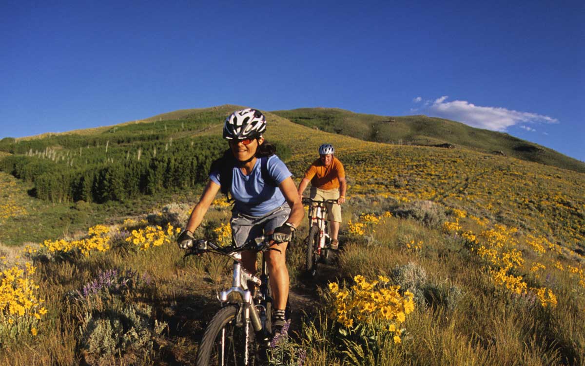
Biking
Mountain Bike Trails
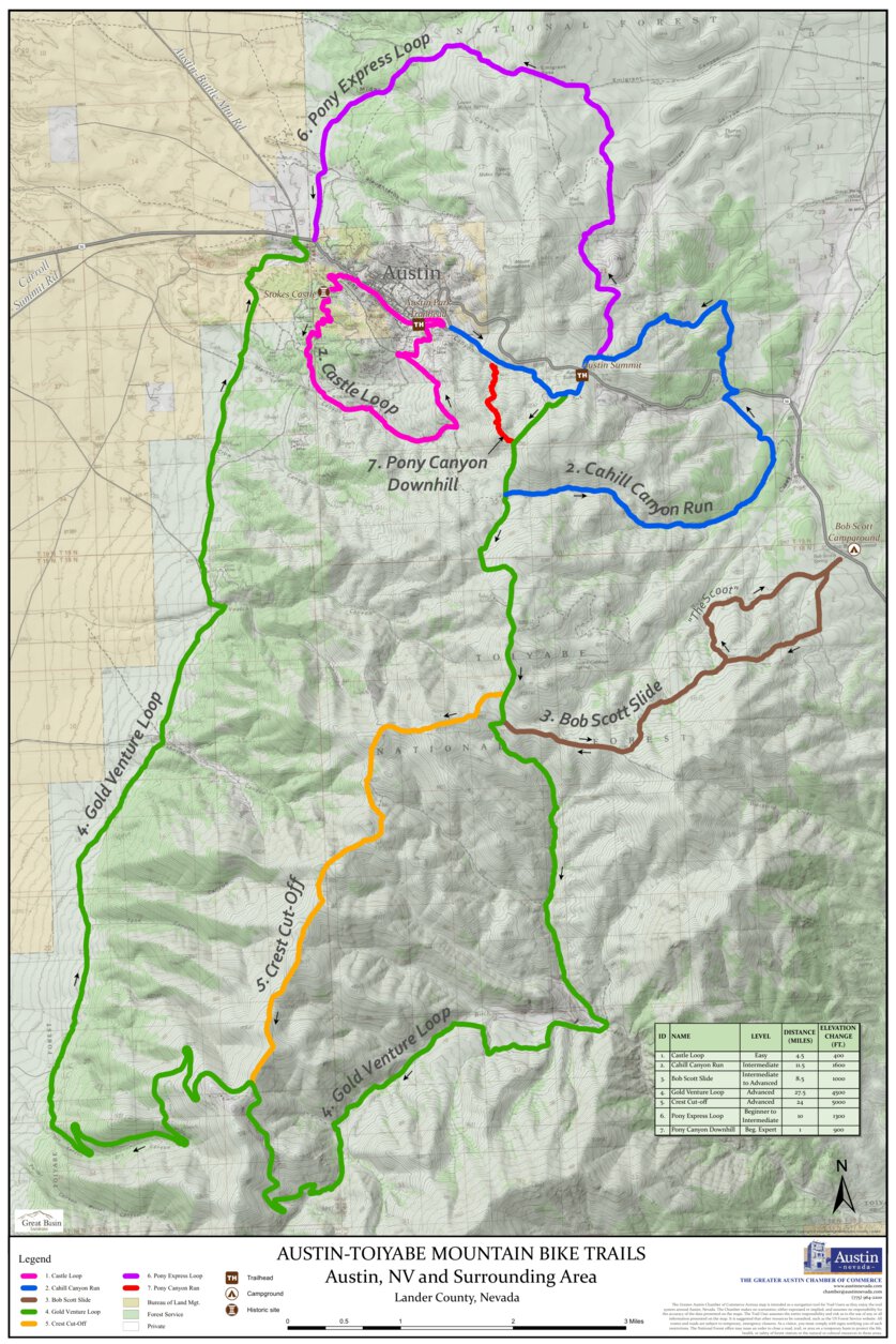
There is a lot to do and see in this area. If you really want to experience it, try one of the mountain bike trails in the Toiyabe Range. The following is an summary of the trails listed in the Austin-Toiyabe Mountain Bike Trail Guide, please refer to the guide for complete directions before taking any of these trails for the first time. (Click each map for enlarged view.)
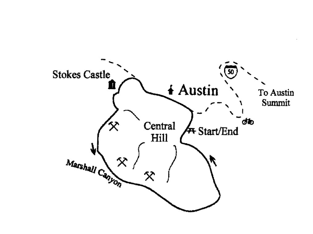
Castle Loop
Level: Easy
Distance: 4.5 miles
Elevation Gain: 400 ft.
Castle Loop begins and ends at Austin park. It is an easy trail for riders just passing through town or as a warm-up for longer mountain rides. This is an especially good trail for beginner and younger riders, because it's never far from town but gives a taste of the many trail possibilities for Austin mountain bikers.
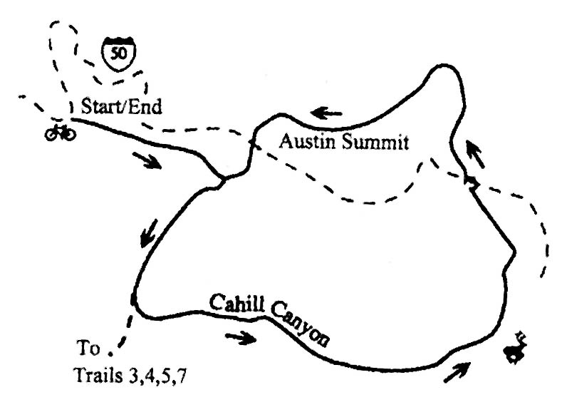
Cahill Canyon Run
Level: Intermediate
Distance: 11.5 miles
Elevation Gain: 1600 ft.
This is a good trail for those looking for a quick, moderate challenge. It begins with a climb toward the Austin Summit, then continues to the south along the ridge of the Toiyabe Range. Watch for the trail marker signs and turn left shortly after the downhill begins as several trails share the ridge. This trail follows an intermittent creek into a woodland of juniper as well as scattered aspen groves. The descent back into Austin is fast and fun.
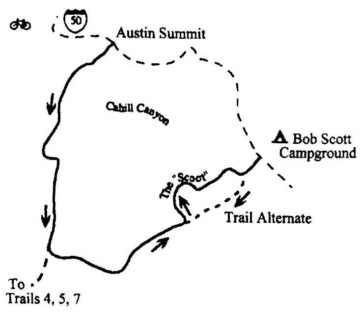
Bob Scott Slide
Level: Intermediate/Advanced
Distance: 8.5 miles
Elevation Gain: 1000 ft.
A challenging climb and descent for intermediate to advanced riders, it starts at Austin Summit and climbs the ridge trail toward the radio towers. This trail continues south and then turns left onto a two-track headed to the Bob Scott campground. It provides a nice challenge for advanced riders and has occasional water crossings at the springs feeding Bade Creek below. If you are camping at the campground, you'll find a nice alternative loop by reversing the course. Veer to the left to the top of the descent for a short loop of approximately 4 miles.
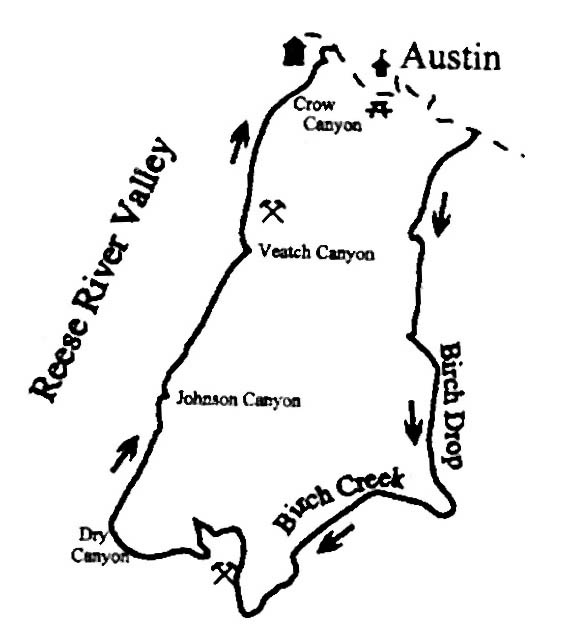
Gold Venture Loop
Level: Advanced
Distance: 27.5
Elevation Gain: 4500 ft.
Designed for cyclists ready for the longer ride in the back country, this trail has steep climbs with long, fast descents. The loop follows the Toiyabe Ridge, past the radio towers, to the top of the drop to Birch Creek. This drop is a great descent! Birch Creek is a beautiful canyon with junipers, aspen, and a multitude of springs. Then get ready to climb out through the canyon on an old pack trail. A mine at the top marks the end of the long climb, then descend through switchbacks to the return trail. There are short climbs at Crow Canyon and Fandango Hill and the winding mine road near stokes castle is fast and fun. The ride ends with a short, steep climb to downtown.
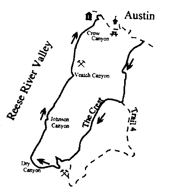
Crest Cut-off
Level: Advanced
Distance: 24 miles
Elevation Gain: 5000 ft.
This is a challenging detour from the Gold Venture Loop. The course has many steep and technical sections, making for a long day on the trail. The Crest Cut-off follows the Gold Venture Loop until just after the radio towers, then veers right and heads up the ridge. Cyclists will works their way up and over several summits and may have some short, single track detours around summit obstacles. The high point of the trail is at 8,934 feet, after which it joins the Gold Venture Loop for the descent and return to Austin.
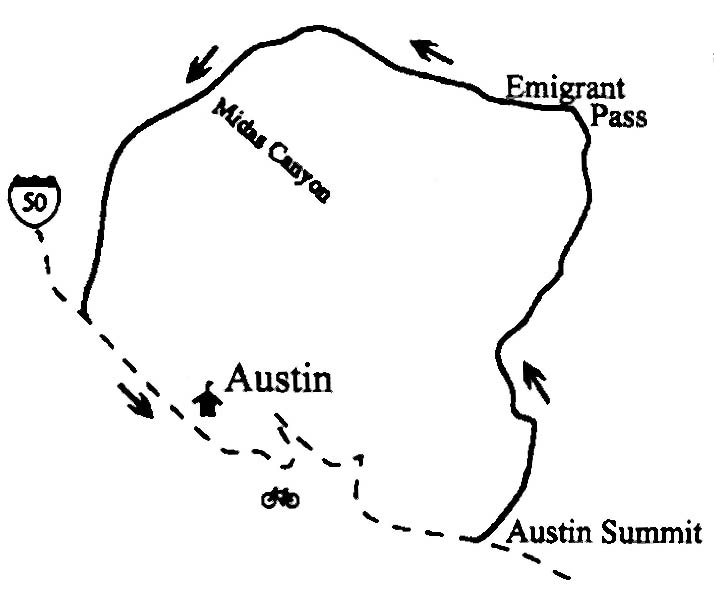
Pony Express Loop
Level: Beginner/Intermediate
Distance: 10 miles
Elevation Gain: 1300 ft.
This loop follows a section of the Pony Express mail route through Emigrant Pass. It begins in downtown Austin and climbs to Austin Summit. (Although it's a good trail for all levels, it does have a few climbs that may be challenging for the beginner. You can avoid most of the climb by starting your ride at Austin Summit.) Then the trail heads north along a rocky two-track and through some grassy spring areas. A sharp left and you're on to the Pony Express route. Once you reach the pass, descend on a return trail to Highway 50 - fast and fun.

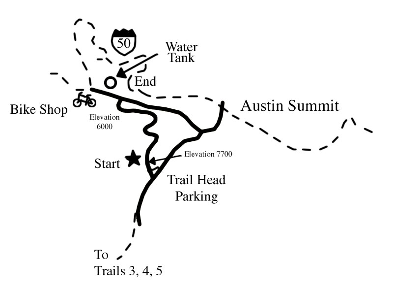
The Pony Canyon Down Hill Trail
Level: Beginner/Expert
Distance: 1 mile
Elevation (down): 900 ft.
The Pony Canyon Down Hill Trail #7 is a permanent downhill trail built in 2000.
Trail Head is located at 1 mile south of Austin Summit along the Cahill Canyon. There is a parking and turn around at Trail Head which provides a spectacular view of Reese River and Austin.
The trail is a very fast down run with great jumps, tight curves, and hair-raising side hills ending at the water tank in Pony Canyon with easy access for pickup to go back up and do it again.
For more information about these and other biking opportunities, contact the Austin Ranger District, Toiyabe National Forest at 775-964-2671, or the Austin Chamber of Commerce at 775-964-2200.
**Maps can be found on Avenza Maps application** Printing recommended prior to trip.